标题: 图谜图记;新疆阿尔苏地貌 [打印本页]
作者: 一片山水 时间: 2018-5-29 13:53
标题: 图谜图记;新疆阿尔苏地貌
[attach]4580698[/attach]
[attach]4580699[/attach]
[attach]4580700[/attach]
作者: 一片山水 时间: 2018-5-29 13:54
[attach]4580701[/attach]
[attach]4580702[/attach]
[attach]4580703[/attach]
作者: 一片山水 时间: 2018-5-29 13:55
[attach]4580704[/attach]
[attach]4580705[/attach]
[attach]4580706[/attach]
作者: 一片山水 时间: 2018-5-29 13:55
[attach]4580707[/attach]
[attach]4580708[/attach]
[attach]4580709[/attach]
作者: 一片山水 时间: 2018-5-29 13:56
[attach]4580710[/attach]
[attach]4580711[/attach]
[attach]4580713[/attach]
作者: 一片山水 时间: 2018-5-29 13:56
[attach]4580715[/attach]
[attach]4580716[/attach]
[attach]4580717[/attach]
作者: 精灵企鹅 时间: 2018-5-29 14:44

作者: 汇泉湾泳客 时间: 2018-5-29 15:33
本帖最后由 汇泉湾泳客 于 2018-5-29 15:35 编辑
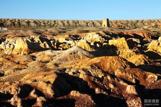
雅丹地貌是一种典型的风蚀地貌,又称风蚀垄槽,或者称为风蚀脊(Yardang)
“雅丹”原是我国维吾尔族语,意为陡峭的土丘。
在极干旱地区的一些干涸的湖底,常因干涸而裂开,风沿着这些裂隙吹蚀,裂隙愈来愈大,使原来平坦的地面发育成许多不规则的背鲫形垄脊和宽浅沟槽,这种支离破碎的地面成为雅丹地貌。有些地貌外观如同古城堡,俗称魔鬼城。
塔里木盆地的罗布泊区域,有些雅丹地形的沟深度可达十余米,长度由数十米到数百米不等,走向与主风向一致,沟槽内常有沙子堆积。在垅脊顶部常有白色盐壳,又称白龙堆。
雅丹地貌以罗布泊西北楼兰附近最典型。世界各地的不同荒漠,包括突厥斯坦荒漠和莫哈韦沙漠在内,都有雅丹地形。
雅丹世称魔鬼城,是最全面地质资料宝库。在繁荣的丝绸古道上,它是一个最大的天然路标。
作者: 七彩阳光 时间: 2018-5-29 15:38
[attach]4580885[/attach]
作者: 鱼象鱼 时间: 2018-5-29 18:09
[attach]4581078[/attach]
作者: 冬晨泳 时间: 2018-5-29 18:12
[attach]4581093[/attach]
作者: 一片山水 时间: 2018-5-31 08:53
[attach]4582260[/attach]
作者: 一片山水 时间: 2018-5-31 08:55
[attach]4582263[/attach]
作者: 一片山水 时间: 2018-5-31 08:55
[attach]4582264[/attach]
作者: 一片山水 时间: 2018-5-31 08:57
[attach]4582266[/attach]
作者: 一片山水 时间: 2018-5-31 09:03
[attach]4582269[/attach]
作者: 汇泉湾泳客 时间: 2018-5-31 14:32


| 欢迎光临 (http://bbs.china-ws.org/) |
Powered by Discuz! X3.3 |
 雅丹
雅丹